- 3D Mesh Service
- 3DML
- Access Permission
- Alert
- AltitudeMethod
- Analysis
- ArcSDE Data Source
- Area
- Automatically Launching Fuser
- Basic Tool
- Callbacks
- Cesium API
- Clients
- Cloud Services
- Configuration Files Importing
- Connecting to Specific Site
- ContourMap
- ContourMode
- Coordinate System
- CreateLocation
- Cursor
- Custom TE4W Application
- Customization
- Customized Configurations
- Defining Tool Functionality
- DirectConnect
- DirectConnect Performance Issues
- DirectConnect Service
- Distance
- Div Element
- DrawPoints
- DrawPolygon
- DrawPolyline
- Editors
- Elevation
- FaceNorth
- Feature
- Feature Service
- FlyAround
- FlyToPosition
- Generating Report
- Granting Edit Access
- GroundClampingMethod
- GTX
- Hardware Requirements
- HASP Key
- HoleOnTerrain
- I3S
- Imagery
- Imagery Layers Loading in Cesium
- Importing Configuration Files
- Installing SGS
- Items
- JumpToPosition
- Layer Properties
- Layer’s Alias
- License Manager
- License Mechanism
- LoadLayer
- Local Hardware Protection
- Localization
- Main
- Maps Service
- Mesh
- Messages
- Migrating to SGS
- ModifyMesh
- ModifyTerrain
- Navigate
- Objects
- OnAbort
- OnAnalysisObjectAdded
- OnAreaToolClosed
- OnDistanceMeasurementFinished
- OnDistanceToolClosed
- OnFinish
- OnMouseMove
- OnPointUpdate
- OnProfileToolClosed
- OnQueryToolClosed
- OnStreamingFinished
- OnViewshedToolClosed
- OnVolumeToolClosed
- Oracle Spatial Data Source Properties
- Point
- Point Cloud Service
- PointCloud
- Polygon
- Polyline
- Position
- Post-Installation Procedures
- PostGIS Data Source Properties
- PostgreSQL
- Product Capabilities
- Profile
- Project
- PropertiesObject
- Public URL
- QGIS Clients
- QualityMode
- Query
- QueryElevationBuffer
- Reroute Requests
- Rerouting
- Return Values
- Running TerraBuilder Fuser
- SameSite Cookies
- Scanning Data Sources
- Services
- Settings
- SG Scanner Data Source Properties
- SG Upload Data Source Properties
- SGS Installation Folder
- SGS Security
- Shadow
- Silent Installation
- Site Bindings
- Skyline Floating License Server
- SkylineGlobe Product Suite
- SkylineGlobe Server Manager Pages
- SkylineGlobe Server Settings
- SlopeMap
- SQL Server Data Source Properties
- Stopping Servers
- Stopping Services
- TBP
- TE4W Tools
- TerraBuilder Project File
- TerraExplorer Desktop
- TerraExplorer for Web API
- TerraExplorer Pro Elements Supported
- TerraExplorerObject
- Terrain Service
- Time
- Token Creating
- Underground
- Uninstalling SkylineGlobe Server
- Updating TB Project
- URL Parameters
- URL Rewrite Configuration
- User Group Properties
- User Groups Adding
- User Properties
- Vertical Datum Files
- VideoOnTerrain
- View Access
- Viewing Messages
- ViewMode
- Viewshed
- Volume
- VolumeClassificationMode
- Web Settings
- WFS Layers
- Windows Service
- WMS Raster Layers
- Workstation Dependent Software License
- Zoom
URL Parameters
Certain TE4W parameters can be defined from the URL query string, including the project to load and the TE4W configuration.
To define these parameters
§ Append the required parameters to the end of your TE4W URL. Multiple parameters can be added using a ‘&' to separate between parameters (e.g., http://www.skylineglobe.com/sg/SiteOne/terraexplorerweb/terraexplorer.html? config=config.kml&catalogid=12345&lang=chinese). Use the format in the examples below for each of the parameters:
§ catalogid – The TE4W project to load. The project is identified by its ID (catalogid) in SkylineGlobe Server.
Note: After publishing a project in TerraExplorer, a dialog box is displayed with the URLs of the Desktop, TE Web, and Mobile projects. The catalogid can be copied from the TE Web URL.
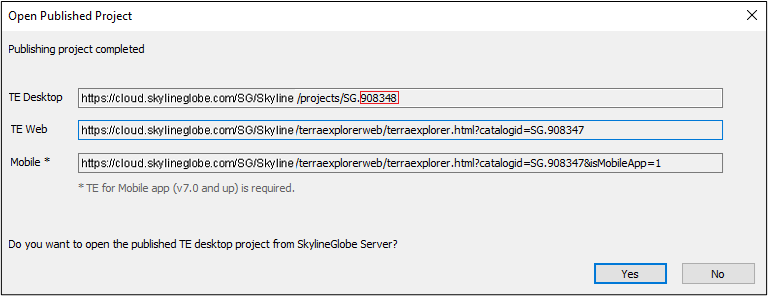
E.g.,
*… /TerraExplorer.html?catalogid=908348
§ config - TE4W configuration that defines various elements of your TE4W including which layers TE4W can connect to, your website subdomains, screen overlay logo, copyright text, and search provider. Customized configurations are created in the TerraExplorer for Web Settings section of the Settings page. See “Creating Additional Customized Configurations” in the “SkylineGlobe Server Settings” chapter for information.
config=[filename]
E.g.,
*… /TerraExplorer.html?config=myConfiguration
Note: See “Setting TerraExplorer for Web Settings” for information on creating customized configurations.
§ position - The position of the camera in which the project should start.
position=[lon,lat,distance,yaw,pitch]
E.g.,
*… /TerraExplorer.html?position=3.205,-14.78,4000,0,-25
§ lang - The user interface language. See "Localization" in this chapter for more information.
lang=[language]
E.g.,
*… /TerraExplorer.html?lang=Russian