General
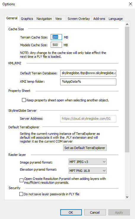
The General tab determines the basic parameters for your TerraExplorer. You can manage disc cache size, define KML/KMZ settings, select raster pyramid formats, and set the currently running TerraExplorer as the default TerraExplorer.

Options - General Tab
|
Parameter |
Description |
|
Cache Size |
|
|
Terrain Cache Size |
Enter the size in MB to be allocated on your hard disk for terrain caching. When you use a terrain from a SkylineGlobe server, data for the area you fly is cached on your local disk. This allows you to fly around this area, without downloading it again. In addition, if you close TerraExplorer and later resume operation using the same internet terrain, information in the cache can be used. |
|
Models Cache Size |
Enter the size in MB to be allocated on your hard disk for 3D models’ automatically generated levels of detail. This option only applies when the Generate levels of detail for 3D models option is selected in the Project Settings General tab. See “General” in the “Setting the Project” chapter for more information. |
|
KML/KMZ |
|
|
Default Terrain Database |
The default terrain database to use when directly opening a KML or KMZ file. |
|
KMZ temp folder |
A temporary folder used to extract compressed KMZ files. |
|
Property Sheet |
|
|
Keep property sheet open when selecting another object |
Select this checkbox ability to keep the properties sheet open when selecting other item from the project tree |
|
SkylineGlobe Server |
|
|
Server Address |
The SkylineGlobe Server that TerraExplorer is currently connected to, or the address of the last server that TerraExplorer was connected to, if you are logged out from the server. This server is used for all SkylineGlobe services including the publishing and reading of layers from server, search functionality and SGS base layers (Read-only). Note: See “Logging In to a SkylineGlobe Server” in the “Working with SkylineGlobe Server” chapter for information on logging in to a server. |
|
Default TerraExplorer |
|
|
Set as Default TerraExplorer |
Sets the currently running instance of TerraExplorer as the default that is associated with the .FLY extension and as the TE version to be used by external applications using TerraExplorer API. This setting can also fix some errors resulting from installation errors or use of other TE versions on the same computer. |
|
Raster Layer |
|
|
Image pyramid format |
Select the required format: § MPT JPEG v3 – For standard imagery. § MPT PNG 24 – For high quality images. |
|
Elevation pyramid format |
Select the required format: § MPT JPEG v3 – For standard resolution. § MPT PNG 16.8 – For high resolution data. § MPT PNG 16 – For very high resolution data. The precision is dynamic according to the range of elevation. |
|
Open Create Resolution Pyramid when adding layers with insufficient resolution pyramids |
Select the check box to automatically open a Create Resolution Pyramid dialog when loading an imagery layer with an insufficient resolution pyramid. |
|
Security |
|
|
Do not save layer passwords in FLY file |
Select this option to provide increased security, by omitting all password information for external sources (e.g., remote servers) from the FLY file. When this option is selected, users will be prompted for password information each time they open the FLY and access the data. |
|
Projection Module |
|
|
Use GDAL v3’s coordinate system reprojection library. This is the recommended option especially when publishing projects to SkylineGlobe Server that will require grid shift files for shifting and transforming between coordinate systems, e.g., for use with TerraExplorer Fusion. Setting will only take effect after closing and reopening TerraExplorer. |
|