Exporting Aerotriangulation Results
You can export your aerotriangulation results either as multiple tiles or as a single unified SQLite, XML, or CSV file.
To export your aerotriangulation results:
1. On the Home tab, in the Process group, click the arrow under Reports and select Export AT. The Export Aerotriangulation Results dialog is displayed.

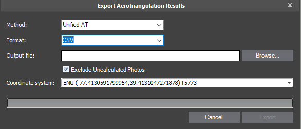
Export Aerotriangulation Dialog
2. In the Method field, select how to export the AT results:
§ Unified AT – Create a single, unified file from all AT tiles for export of AT information into a single set of AT results for each photo and camera. The unified AT includes the average AT results for photos/cameras that participate in more than one AT tile .
§ Multiple AT Tiles – Export each AT tile to a separate file.
§ Create a unified AT (see description above) + generate undistorted photos based on the distortion parameters calculated in the AT process. When photos are captured, most suffer (radial/tangential) distortion, as a result of the shape of the lens and other lens properties, that causes the photos’ straight lines to appear deformed or curved unnaturally, particularly at the photos’ edges.
3. Select a Format:
§ Blocks Exchange XML – An open exchange format for import/export of AT data.
§ SQLite - Skyline internal format for import/export of AT results.
§ CSV – Comma Separated Value format that can be easily created, read or manipulated as well as read in other systems and custom readers.
4. In the Output File field, click Browse, and then in the Save Aerotriangulation Results dialog, do the following:
a. Browse to the folder in which you want to save the AT results.
b. Type the File Name for your results, and click Save.
Note: If the results are being exported as multiple tiles, the naming system for each of the tiles is as follows: File Name_AT_Tile-]Tile #[, e.g., FileName_ AT_Tile-0-0-1-1.xml, FileName_ AT_Tile-0-1-1-1.xml, etc.
5. If you want to exclude uncalculated photos from the exported AT results, select the check box. If uncalculated photos are not excluded, they are exported with original position and orientation values.
6. If you selected CSV format, select the coordinate system for the export. The default coordinate system for CSV is ECEF.
7. Click Export.