Distance Tool
The Distance tool allows you to measure the aerial distance, elevation difference and slope between two or more points. The aerial distance is the actual distance between the points.
To use the Distance tool:
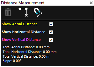
1. On the Tools tab, in the Measure group, click Distance. The Distance Measurement dialog is displayed with the following options regarding display of distance information in the 3D Window:
Note: The aerial, horizontal, and vertical distance information are calculated and displayed in the Distance Measurement dialog even if the respective option was not selected
§ Show Aerial Distance – Show a yellow line marking the aerial distance, i.e., the actual distance between points, in the 3D Window.
§ Show Horizontal Distance – Show a white line marking the horizontal distance between points in the 3D Window.
§ Show Vertical Distance – Show a purple line marking the vertical distance between points in the 3D Window.

Distance Measurement Dialog
2. If you want to snap the measurement points to an object’s edge or vertex, click Snap ![]() . All edges, i.e., intersections of two plane faces, and vertices, i.e. intersections of two polylines are automatically detected.
. All edges, i.e., intersections of two plane faces, and vertices, i.e. intersections of two polylines are automatically detected.
3. In the 3D Window, click any point on the terrain or on an object to define the start point of the measurement. A yellow line extends from the start point. Drag the cursor to the next point and click again. Repeat to add as many segments as required. If you want to delete the last point added, click Delete Point ![]() . Right-click to finish the measurement.
. Right-click to finish the measurement.
The Distance Measurement dialog displays the following measurements:
|
Measurement |
Description |
|
Total Aerial Distance |
The aerial distance, i.e., the actual distance between the points. This measurement is the sum of the aerial distances between the points as you progress from the start point to the endpoint. |
|
Total Horizontal Distance |
The horizontal distance between the points. This measurement is the sum of the horizontal distances between the points as you progress from the start point to the endpoint. |
|
Total Vertical Distance |
The difference in elevation between the points. If you have marked more than two points, this measurement does not take into account the elevation values of the middle points. |
|
Slope |
The slope of the line between the first and last points. If you have marked more than two points, this measurement does not take into account anything other than the elevation at the start point and the elevation at the endpoint. |
4. If you want to delete the measurement polyline in the 3D Window, click Delete ![]() .
.
5. To perform additional distance measurements, repeat steps 2-3 above.
6. To close this tool, click the X on the top right corner of the dialog.