Area Tool
Using the Area tool, you can calculate area on the terrain or on an arbitrary plane.
To use the Area tool:
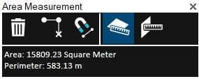
1. On the Tools tab, in the Measure group, click Area. The Area Measurement dialog is displayed.

Area Measurement Dialog
2. Click either of the following commands:
§ Horizontal plane area (2D measurement) ![]() - Calculate area on terrain. The area measured is the horizontal projection of the area you have outlined, even if some or all of your selected area encompasses mountainous terrain.
- Calculate area on terrain. The area measured is the horizontal projection of the area you have outlined, even if some or all of your selected area encompasses mountainous terrain.
§ 3D plane area ![]() - Calculate area on an arbitrary plane. The polygon’s orientation is determined by the first three points selected.
- Calculate area on an arbitrary plane. The polygon’s orientation is determined by the first three points selected.
3. If you want to snap the measurement points to an object’s edge or vertex, click Snap ![]() . All edges, i.e., intersections of two plane faces, and vertices, i.e. intersections of two polylines are automatically detected.
. All edges, i.e., intersections of two plane faces, and vertices, i.e. intersections of two polylines are automatically detected.
4. Draw a polygon in the 3D Window that defines the borders of the region being measured:
§ Place the polygon points in the 3D Window by clicking in the desired locations. A red line extends from the start point. If a valid selection area was drawn, the line turns white after the third click, indicating that you can then right-click and obtain the required measurement. A minimum of three points must be selected. If you want to delete the last point added, click Delete Point.
Note: If the boundary line of the measured area crosses itself, it turns red, and a dialog is displayed informing that the polygon is invalid.
5. Right-click to finish the measurement. The Area dialog displays area and perimeter measurements.
6. If you want to delete the area polygon in the 3D Window, click Delete ![]() .
.
7. To perform additional area measurements, repeat steps 2-5 above.
8. To close this tool, click the X on the top right corner of the dialog.