Herndon, Virginia— May 10, 2024 — Skyline Software Systems Inc. is excited to announce the releases of SkylineGlobe Server and TerraExplorer Fusion 8.1. Every installation of SkylineGlobe Server now includes the capability to upgrade to TerraExplorer Fusion Plus level. This upgrade occurs dynamically in TerraExplorer Fusion when a project is accessed from a SkylineGlobe server with an active Plus license. The Plus license grants Plus capabilities across the server, while allowing for the selective restriction of certain sites to Viewer-only mode. TerraExplorer Fusion includes some game-changing features including:
Advanced Analysis Tools
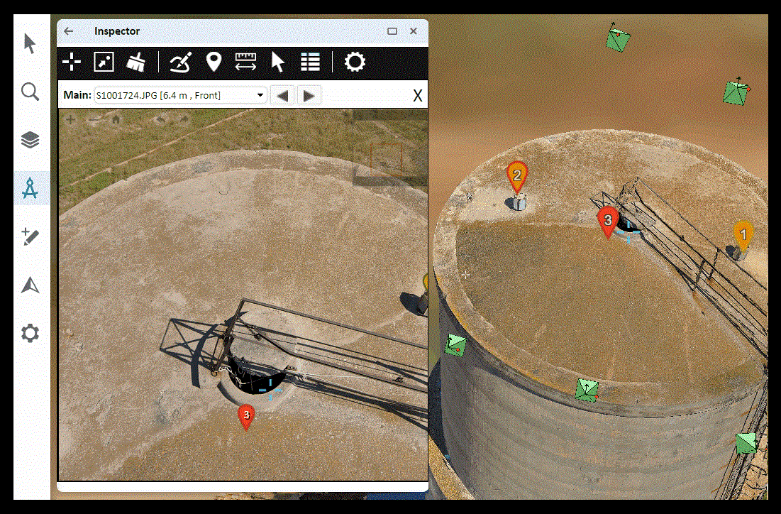
The enhanced features included in the Fusion Plus toolset bolster TerraExplorer Fusion’s analysis capabilities significantly, rendering them nearly on par with those of TerraExplorer Desktop. Key additions include the Photo Inspector tool, which enables detailed inspection of your PhotoMesh 3D models (e.g., towers, bridges, construction sites) together with their source photos. Users can easily navigate within the model and between the model and its associated photos, and mark up or take measurements in the model.
Other exciting tools included in the Plus version are “High and Low” and “Clear Path”. The High and Low tool visually represents elevation differences within a selected area by colorizing the highest and lowest regions based on user-specified percentage thresholds. For instance, setting a top percentage of 15% and a bottom percentage of 10% will cause the tool to highlight the uppermost 15% and the lowermost 10% of the area, clearly delineating these elevation extremes. The Clear Path tool enhances navigational planning by identifying optimal locations for specific uses, such as helicopter landing zones or vehicle routes, based on predefined criteria within a given search radius.
Load and Style Layers
TerraExplorer Fusion Plus allows for loading of all layer types from SkylineGlobe Server—3DML, elevation, feature, imagery, point cloud, or raster complex. A variety of styling options are also supported including line and fill color, altitude options, tooltips and more.
Publish and Share
In TerraExplorer Fusion Plus, users with ‘Publisher’ level permissions for SkylineGlobe Server can now publish to SGS all contents in their “My Data”, including custom locations, measurement objects and layers added to the project. When subsequently loading this published data into TerraExplorer Fusion, users can choose to do so as ‘Open base project’, combining “My Data” with the original base project, or as an “Open as Layer” option, which loads only the “My Data” section into the existing project.
Feature Editing
Users with edit permissions can add new point, line, and polygon features, and edit their geometry and attribute data. TerraExplorer Fusion Plus supports powerful tools for analyzing and filtering your feature layer data. Features can be selected based on their spatial relationship with a user-drawn polygon, line or point, or alternatively, using the Attribute Table to select features based on their attribute values. Plus, all changes are now saved automatically to streamline the editing process.
For an in-depth look at our new developments, see our TerraExplorer Fusion Release Notes and our SkylineGlobe Server Release Notes.
